“Likely and imminent”: Yarra Ranges council adds almost 2,000 properties to new landslide planning restrictions
The new mapping would see a net increase of 1,987 properties under new planning restrictions increasing the total number of affected properties to 13,434.
Matthew Sims
July 17, 2025
Almost 2,000 Hills properties will be added to the Yarra Ranges Council erosion risk zone, placing more planning restrictions on homeowners, following fears of "likely and imminent" landslides.
The work follows on from a significant storm which hit communities across the Hills in June 2021, damaging close to 200 properties due to falling trees.
Why is erosion increasing?
University of Melbourne School of Earth Sciences Professor Antoinette Tordesillas said inland erosion has increased due to a number of factors.
“Erosion gets worse when we see more intense and frequent storms or heavy rainfall, which is becoming more common with climate change,” she told the Eastern Melburnian.
“Bushfires, construction, land clearing, logging, overgrazing, and even off-road driving can damage the soil and make it easier for it to wash or blow away.”
Tordesillas said it was time for all authorities to consider how to plan moving forward, from the ground up.
“Indigenous Australians have long practiced a philosophy known as “Caring for Country,” which is all about living in balance with the land,” she said.
“We can learn from this by nurturing our soil, planting and keeping more native vegetation, and making sure the ground stays densely covered and healthy.”
Tordesillas said the most important thing to remember about soil erosion was that it was constantly changing.
“It’s important that we monitor areas prone to soil erosion regularly,” she said.
"Thanks to satellite data and AI, we can now track things like soil moisture, land movement, and rainfall in near real time and across vast areas of land --- to extract fast, precise and customised solutions to many of these problems.
“This helps us respond quickly and make smarter land management decisions as weather patterns shift.”

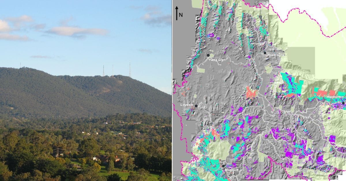
What does the Erosion Management Overlay (EMO) do?
A Yarra Ranges Council spokesperson said an EMO was a planning scheme control which applies to land identified as at risk of landslip or debris flow.
“Debris flow is when wet soil and debris move quickly down a slope, usually through a gully,” the spokesperson said.
“It's different from a landslide, which moves slower and is less risky to people but can damage property.
“Yarra Ranges has a history of landslip risk, with several identified landslip sites including Warburton, the Dandenongs and Montrose.”
The spokesperson said the overlay contained requirements for how to develop land safely to protect people and their homes.
“The EMO helps prevent unsafe building and earthworks on land that could have landslides by requiring a planning permit for any new development.”

What will change as part of the new EMO?
The amendments would result in a net increase of 1,987 properties, increasing the total number of affected properties to 13,434.
That would mean an additional 3,172 properties identified as vulnerable, with 1,185 properties identified as at-risk by the old modelling removed.
The updated overlay is the result of extensive work, partially funded by $300,000 in grant funding under National Emergency Management Australia’s Preparing Australian Communities program.
“The current mapping was prepared in the 1990s and mostly based on 1960s contour plans and old aerial photography,” the Yarra Ranges Council spokesperson said.
“Council has contracted geotechnical experts to analyse landslide and debris flow risks across the Yarra Ranges.
“New technology has been used which has now provided the council with more accurate mapping.”
The report said the next significant rainfall event or landslide could come at any time.
“There are no certainties about when the next significant rainfall event or landslide could occur,” the report said.
“However, given recent weather patterns and high instance of emergencies in Yarra Ranges, it is reasonable to consider this likely and imminent.”
The Eastern Melburnian understands Yarra Ranges Council received authorisation to prepare the amendment to the council’s Planning Scheme on Friday, June 27, with the council now preparing documentation towards undertaking public exhibition in due course.

Why is Mount Dandenong at risk of landslides?
Volcanic activity around 370 million years ago helped form the foundations of Mount Dandenong, with a volcanic rock called rhyodacite making up most of the underlying composition.
While initially a high-strength rock resistant to erosion, the rhyodacite has undergone a process called “chemical weathering”, where the minerals that make up the rock transform to red-brown clay after being exposed to the atmosphere.
Geological evidence points to Mount Dandenong being impacted by landslides for hundreds of thousands of years, with the first documented landslides occurring in the 1860s and one of the most recent occurring in Ferny Creek in January 2024.
If a landslide does occur, people should seek refuge away from the site and call 132 500 for SES emergency assistance, or 000 in a life-threatening emergency.